For a changing world

Environmental Sensors

As the world increasingly focuses on protecting our natural heritage, we’re proud to introduce our new range of environmental sensors.

Built on decades of experience designing robust outdoor equipment, our multi-sensor solutions make it easy to monitor your environment reliably and accurately.

We work closely with clients to deliver tailored systems that provide the insights needed to manage and protect natural spaces effectively.
STEP 1:
Choose your sensors to connect
to the datalogger

Build up your Environmental Sensor Unit
Introducing our rugged, battery powered datalogger for environmental monitoring. Ideal for water, air, and soil analysis. It performs reliably in harsh conditions and remote locations. With sensor compatibility and easy data retrieval. Our units can provide accurate insights for research, management and compliance
Barometric pressure monitoring is important because it helps track changes in atmospheric pressure, which are key indicators of weather patterns. It can be used to predict storms, changes in weather, and even extreme events like hurricanes or tornadoes. Monitoring barometric pressure also aids in altitude and elevation measurements, which is essential for aviation, mountain climbing, and understanding environmental conditions. Additionally, it can help in scientific research, such as studying climate patterns and improving weather forecasts.
Measuring humidity is important for maintaining comfortable and healthy indoor environments, preserving materials, and ensuring accurate weather forecasting. It helps prevent issues like mold growth, respiratory problems, and material degradation caused by excessive moisture, while also playing a key role in human comfort and weather prediction.
Measuring rainfall is important for a wide range of applications, from informing daily activities to long-term climate research. It helps in understanding weather patterns, predicting floods and droughts, managing water resources, and supporting agriculture.
Monitoring temperature is important because it helps track weather patterns and seasonal changes, which are essential for predicting storms, heatwaves, and cold fronts.

Temperature data also plays a critical role in agriculture, affecting crop growth and irrigation needs. Additionally, temperature changes can impact ecosystems, water resources, and wildlife, influencing the timing of migrations, breeding, and plant blooming.

It supports energy management by affecting heating and cooling demands and is vital for climate research.
Measuring water levels in a river is crucial for monitoring environmental health, managing water resources, and ensuring public safety. It provides vital data for predicting floods, managing droughts, and supporting irrigation systems. Water level measurements help track seasonal changes, detect trends caused by climate change, and guide infrastructure planning, such as bridges and dams. Accurate, real-time monitoring also supports emergency response efforts, protecting communities and ecosystems dependent on the river.
Measuring river height, also known as river stage, is crucial for flood prediction, water resource management, and environmental monitoring. It helps assess potential flood risks, manage water levels for agriculture and other uses, and understand river ecosystem health.
Measuring solar radiation, specifically solar irradiance, is crucial for various applications including optimizing solar energy systems, understanding climate change, and designing buildings for optimal thermal performance. Accurate measurements help in predicting energy output, maximizing efficiency, and making informed decisions across different sectors.

Build Your Environmental Sensor Unit with the Options Below

Measuring water table levels is crucial for environmental health, water resource management, and is vitally important in peatland restoration. Peatlands rely on saturated conditions to prevent decomposition and allow carbon capture. Maintaining these high water tables therefore supports native vegetation, curbs greenhouse gas emissions, and enhances biodiversity.
Rainfall measurement is essential for managing water resources, predicting floods and droughts, and supporting agriculture. It informs climate models, helps track environmental changes, and guides infrastructure planning. Accurate data ensures sustainable land use, protects ecosystems, informs meteorology and enhances disaster preparedness in a changing climate.
Barometric pressure monitoring tracks atmospheric changes for weather prediction, including storms and extreme events. This sort of data is essential for tracking meteorological phenomena. It also aids in altitude measurements for aviation and mountain climbing, and supports scientific research into climate patterns and weather forecasting.
Humidity measurement is key for comfortable, healthy indoor environments, material preservation, and accurate weather forecasting. It prevents mold, respiratory issues, and material degradation, while also impacting human comfort and weather prediction. Throughout the history of mankind, humidity levels have been a pivotal issue and they continue to remain important.
Measuring solar radiation, is crucial for various applications including optimizing solar energy systems, understanding climate change, and designing buildings for optimal thermal performance. Accurate measurements help in predicting energy output, maximizing efficiency, and making informed decisions across different sectors.
Monitoring temperature tracks weather patterns and seasonal changes, essential for predicting storms and heatwaves. It's critical for agriculture, impacting crop growth and irrigation, and influences ecosystems, water resources, and wildlife. Temperature data also supports sustainable energy management and cutting edge climate research.
Measuring river height and flow is critical for managing water resources effectively, predicting and mitigating flood risks, and understanding the health of aquatic ecosystems. This data informs agricultural practices, supports navigation, and aids in planning infrastructure like bridges and dams, ultimately ensuring public safety and environmental sustainability.
Soil moisture content is crucial for plant health, agricultural productivity, and ecosystem stability. It influences root growth, nutrient uptake, and microbial activity. Monitoring soil moisture helps manage irrigation, predict droughts, and optimize land use. It also supports climate resilience by informing water conservation and sustainable farming practices.

Environmental Sensor Units

What our sensors can monitor

All sensors will transmit metrics to the data logger and then straight to your chosen data delivery service
STEP 1:
Build up your Environmental Sensor
Measuring river water levels is crucial for environmental health, water resource management, and public safety. It aids in predicting floods, managing droughts, and supporting irrigation. Accurate monitoring helps track changes, detect climate trends, and guide infrastructure planning, supporting communities and ecosystems.
Humidity measurement is key for comfortable, healthy indoor environments, material preservation, and accurate weather forecasting. It prevents mold, respiratory issues, and material degradation, while also impacting human comfort and weather prediction.
Measuring river height and flow is critical for managing water resources effectively, predicting and mitigating flood risks, and understanding the health of aquatic ecosystems. This data informs agricultural practices, supports navigation, and aids in planning infrastructure like bridges and dams, ultimately ensuring public safety and environmental sustainability.
Measuring solar radiation, specifically solar irradiance, is crucial for various applications including optimizing solar energy systems, understanding climate change, and designing buildings for optimal thermal performance. Accurate measurements help in predicting energy output, maximizing efficiency, and making informed decisions across different sectors.
Barometric pressure monitoring tracks atmospheric changes for weather prediction, including storms and extreme events. It also aids in altitude measurements for aviation and mountain climbing, and supports scientific research into climate patterns and weather forecasting.
Monitoring temperature tracks weather patterns and seasonal changes, essential for predicting storms and heatwaves. It's critical for agriculture, impacting crop growth and irrigation, and influences ecosystems, water resources, and wildlife. Temperature data also supports energy management and climate research.
Rainfall measurement is vital for daily activities and climate research, aiding in understanding weather, predicting floods/droughts, managing water, and supporting agriculture.
STEP 2:
Choose your Data Delivery
System

Satellite datalogger

This data logger uses the latest satellite technology for remote data retrieval, eliminating the need to visit counters. The satellite logger operates in all locations, including those with weak or no mobile network coverage.  When using our satellite solution we are able to monitor the battery and sensor signal strength remotely from the web portal to ensure that the counters are working optimally.Available with our full outdoor counter range, we are currently the only providers of satellite data transfer in the UK.

LoRa Wan Data Delivery

Our Local Wireless Solution which uses a robust and high performing wireless network that transmits the count data to a receiver attached to a LAN network or host PC.  Available with our full outdoor counter and indoor counter range.

Open collector

The software we provide with the datalogger version is Windows-based and intuitive. It provides a graphical view of the data when the logger is connected, providing immediate feedback. It also provides basic statistics (maximum, average counts, etc) and a table of the data. However, most customers export the data as a *.csv file for import to other programmes such as Excel or their management information system.

LCD Display

An LCD display is most commonly used for indoor counters. After manually logging the number the unit can easily be reset with the provided magnet.This version of data delivery is best for locations where there is someone who can log the counts on a regular basis, such as libraries, shops, visitor centres etc.

Manual data logger

Our manual  download data logger gives you count information that is easily downloaded onto a computer using a USB cable from the logger to the PC/laptop.

The download of the data is easy and can be undertaken in-situ or in the office, or the loggers can be swapped in the field. Data from multiple counters can be downloaded into a single file for easy comparison between entrances/sites.

Mobile Network Data Delivery

We can incorporate mobile data loggers such as NB IoT or GSM for remote data retrieval, eliminating the need to visit counters. As mobile network coverage improves, this is a good cost-effective option where signal strength is reliable.

Step 2
Choose how to receive your Data

Powerful Data
Delivery For All Sensors

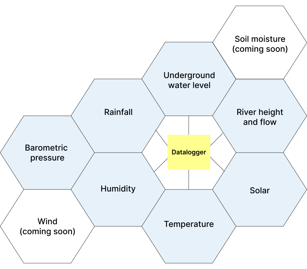
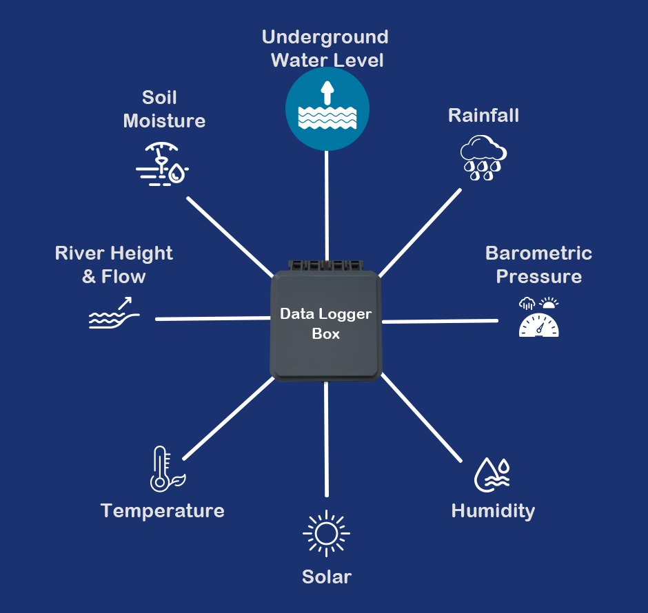
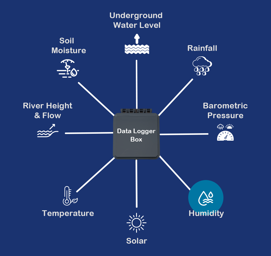
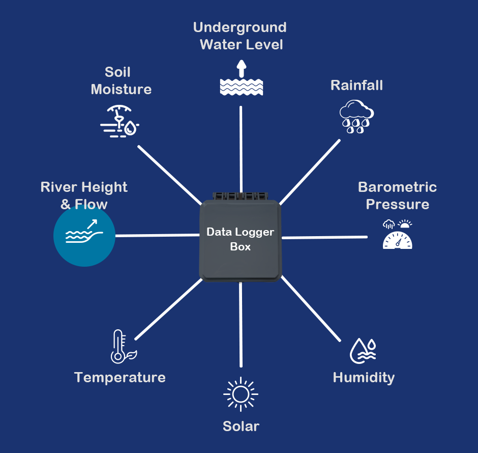
Once you have chosen the sensors you wish to connect to your Datalogger box, you can select the data delivery system that works best for you.

With our remote logger solutions manual uploading of sensor data can be a thing of the past.

We are always happy to offer guidance if you're unsure which data delivery system is optimal for your project, providing you with all the information you need to make the best decision

Remote Data Delivery

Data delivered straight to your PC means no need for regular site visits. 

Satellite
NB IoT
LoRa

On Site Data Collection

Avoid ongoing data delivery costs by retrieving count data manually

LCD Display
Manual Datalogger

Water Level Loggers

As a response to the growing concern for peatland conservation, we have upgraded our water level logger to be an ideal solution for capturing underground water table levels in even the remotest of locations without costly site visits, thanks to our unique provision of satellite remote logging.

Healthy peatland requires the water level to be no more than 1m below the surface and this can be monitored more easily than ever before. Our water level logger can equally be used in rivers or flood lands to record how water levels change over time and we can tailor the device to meet your own depth and data delivery needs.

Satellite Water Level Logger WLL-S

Our Water Level Logger has been designed to measure the water height in harsh environments such as peat bogs, rivers, and flood plains. Ground water level data will be automatically sent via a satellite link and displayed on a web hosted dashboard, meaning no mobile signal is required for remote logging.

The unit is robust and has a very long operating life. There are no external cables that can be damaged by rodents, weathering etc.

When powered, the system will automatically send the GPS location of the unit and begin logging. The user can simply leave the probe secured within the dip-well with no further support required, other than infrequent cleaning of the protective filter.

We have also added temperature and humidity sensors to enhance data analysis.

Depth Range:

0 to 1.4 metre

Information Stored:

Water depth in 5mm increments
Data and Time
Temperature
Humidity
GPS Location

Battery Life:

Up to 5 years

Data Delivery

Satellite data transmission
Logging Interval: 3 to 12 hours
Data Transmission Rate: Once per day

Housing and Dimensions

Transducer pipe: 22mm (diam) x 1500mm (or as required)
Control box: 188mm x 188mm x 130mm

Electronic Marking System

The electronic marking system is a proven radio-detection solution for discretely marking and monitoring locations on the ground, including archaeological sites, vegetation quadrats, and areas prone to erosion. Small, durable transponders are buried at each location and detected by the retriever unit, providing a long-lasting, reliable marking method. Now widely used nationwide for long-term monitoring, the system features a pinpoint mode, which can be added to existing units through an upgrade. Flexible and robust, the retriever system makes tracking and revisiting critical sites simple and accurate.

Water Level Loggers

As a response to the growing concern for peatland conservation, we have upgraded our water level logger to be an ideal solution for capturing underground water table levels in even the remotest of locations without costly site visits, thanks to our unique provision of satellite remote logging.

Healthy peatland requires the water level to be no more than 1m below the surface and this can be monitored more easily than ever before. Our water level logger can equally be used in rivers or flood lands to record how water levels change over time and we can tailor the device to meet your own depth and data delivery needs

Electronic Marking System

The retriever system is the well proven radio-detection system for invisibly marking locations on the ground, such as archaeological sites and vegetation quadrats. A small transponder is buried at the location and is activated and detected by the Retriever Unit. The Transponders have indefinite life. The system is now widely used throughout the country for long-term monitoring. The Retriever Unit has a Pinpoint mode and we are offering to update existing units to add this feature. The system can also be used for monitoring path erosion or marking archaeological sites.

Archive Monitoring System

Our archive monitoring system is purpose-built for museums, archives, and libraries, helping institutions maintain optimal environmental conditions for the preservation of valuable and sensitive materials. Users can configure custom thresholds for temperature, humidity, and other key parameters in line with archival standards. If any of these limits are breached, designated personnel are directly notified through our intuitive online dashboard. This proactive alert system ensures rapid response to environmental changes, safeguarding collections from potential damage and supporting long-term conservation efforts.

Data Delivery

Click the link below to view Data Delivery Options